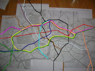
BEHOLD:
The London Tube Map superimposed on the Actual London City Map:

Before you run for the phone to congratulate me, let me just give you a quick list of hardships I had to endure to complete this task. (Lest I be bogged down by uninformed, repetitive questioning.)
- Until Google Earth went global (ha ha, get it?), it was very hard to get a street map of London. They are not free, anywhere, ever. All the hotels and hostels hand you Tube maps, which as you can see from my brilliant visual, are not geographically accurate. The airline magazines don't even print accurate London maps.
- Google Maps was a bit bitchy this afternoon and would only let me print one map at a time, shutting down Firefox each time because of "illegal maneuvers." This made the jigsaw-map technique quite difficult.
- Tube Maps print text very, very small.
- Stomach flu.
- Seventeen third graders.
- Getting a masters degree.
In case you are for some reason not familiar with the London Tube map, I've provided it for you here, along with a real-color copy of my own superimposition. Just see if YOU could navigate a curvy and roundish sprawling city with a straight line map that lacks streets:


PS: If you would like more information about the Underground, or if you want to see someone do a map that is far better than mine, go here.
No comments:
Post a Comment